River Map
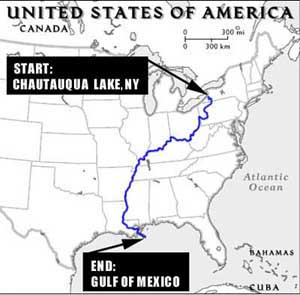 The WaterWorks journey begins on Chautauqua Lake in New York State. The 20-mile long lake is drained by the 8 mile long Chadakoin River which flows briefly into the Cassadaga Creek, whereupon it joins the 33 mile length of the
Conewango River. The
Conewango
joins the Allegheny River in Warren, PA which flows 190 miles to Pittsburgh. In Pittsburgh, the confluence of the Allegheny and Monongahela Rivers creates the Ohio River which winds its way 981 miles to Cairo, IL and the Mississippi River. The Lower Mississippi River meanders 954 miles south from Cairo to where it spills into the Gulf of Mexico. The distance of the entire journey from beginning to end is approximately 2,190 miles. The rivers flow through or adjacent to 12 different states including New York, Pennsylvania, West Virginia, Ohio, Kentucky, Indiana, Illinois, Missouri, Tennessee, Arkansas, Mississippi, and Louisana.
The WaterWorks journey begins on Chautauqua Lake in New York State. The 20-mile long lake is drained by the 8 mile long Chadakoin River which flows briefly into the Cassadaga Creek, whereupon it joins the 33 mile length of the
Conewango River. The
Conewango
joins the Allegheny River in Warren, PA which flows 190 miles to Pittsburgh. In Pittsburgh, the confluence of the Allegheny and Monongahela Rivers creates the Ohio River which winds its way 981 miles to Cairo, IL and the Mississippi River. The Lower Mississippi River meanders 954 miles south from Cairo to where it spills into the Gulf of Mexico. The distance of the entire journey from beginning to end is approximately 2,190 miles. The rivers flow through or adjacent to 12 different states including New York, Pennsylvania, West Virginia, Ohio, Kentucky, Indiana, Illinois, Missouri, Tennessee, Arkansas, Mississippi, and Louisana.